| HeyWhatsThat Cosmic Visibility Frequently Asked Questions |
| Home Planisphere Cosmic Visibility General FAQ and Site Map |
This is the Cosmic Visibility FAQ for HeyWhatsThat.com. Be sure to visit the main site, whose mission is to tell you the names of the mountains you can see when you're standing almost anywhere in the world, and the general FAQ, which lists all the features HeyWhatsThat has to offer. And please sign up for our occasional email announcements.
If you're interested in the night sky, you may want to take a look at our eclipse site for simulations of lunar and solar eclipses, and the planisphere (FAQ) site, where we overlay your horizon and the planets in Google Earth.
Why isn't it working with my browser?
We develop and debug this site with Firefox, so the layout might be incorrect and some features may not work if you're using a different browser.What's the true horizon?
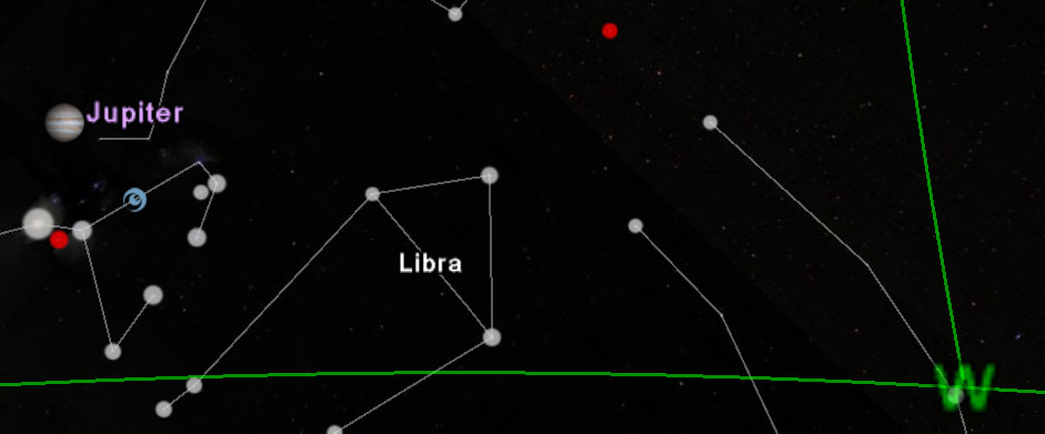
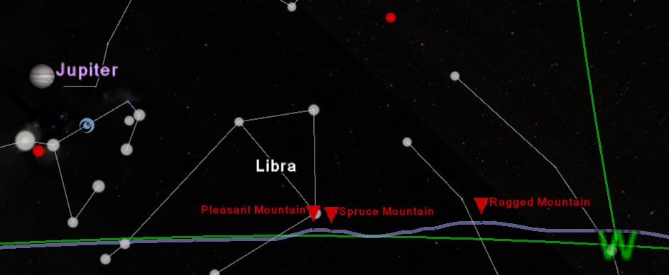
Anyone can generate a sky map assuming a flat horizon. HeyWhatsThat can go a step further. Because we've built the machinery to calculate the panorama from anywhere in the world, we can overlay that panorama on the sky. Here's the difference (in our Google Earth Planisphere):
| Flat horizon | |
| True horizon | |
Why don't I see the true horizon?
To show the true horizon, we must first calculate the panorama for your location. Go to the New Panorama tab on our home page and enter the appropriate information. When the computation finishes, hit the Night Sky view button. (Or, to view the night sky in Google Earth, hit the View in Google Earth at night button.)Why don't I see any planets?
We currently store position data for the Sun, Moon and planets only for 2007 through 2015. So if you specify a time eariler or later than that you won't see any solar system objects.How accurate are planetary positions?
The horizon line does not include the effects of astronomical refraction, which raises stars along the horizon by about one half of a degree, and should therefore depress the horizon line by that amount. (It does however include the much smaller effects of terrestrial refraction on the altitude of the terrain that forms the horizon, as described in the technical FAQ.)We currently store position data for the Sun, Moon and planets only for 2007 through 2015. If you specify a time earlier or later than that, you won't see any solar system objects. We store those positions -- right ascensions and declinations computed by NASA JPL's HORIZONS System -- at one minute intervals for the Moon and ten minute intervals for all other objects and interpolate linearly within those intervals.
We compute the topocentric position for the Moon and Earth shadow, but use geocentric positions for all the other objects (i.e. we place the Moon in its proper place in the sky based on the observer's location on the surface of the Earth, but everything else is still shown where it would be if you were standing at the center of the Earth, because it makes so little difference).
There is no attempt to incorporate the actual axial tilt of the planets' rotations.
The Horizons system can provide planet position data for dates between 3000 BC and 3000 AD; please get in touch if you're interested in something earlier or later than the next two years.
How accurate are the shadows and masks?
To draw the visibility and shadow masks, we've queried NASA JPL's HORIZONS System for a variety of quantities. For example, to draw the mask representing the portion of the Moon visible from the Earth, we grab the lat/lon on the Moon that's in direct line with the Earth at a given moment. Then the visible portion of the Moon is roughly the hemisphere centered at that point. Similarly, for the mask representing the illuminated portion of the Moon, we grab the lat/lon on the Moon in direct line with the Sun. We've downloaded these values for 2007 through 2015 at one minute intervals.These visualizations do not handle eclipses.
We don't include the effect of diurnal libration, which means we don't take into account that people on opposite sides of the Earth see slightly different Moons (one can see a bit more around the left edge of the Moon, the other the right).
The Sun illuminates a full hemisphere of the Moon.
The Sun illuminates a bit more than a full hemisphere of the Earth. We assume that atmospheric refraction at the horizon is 34' and the apparent radius of the Sun is 16', so the Sun doesn't disappear until its center is 50' below the horizon. Then geometry tells us the angular radius of the lit portion is not 90° but 90° 50'.
From the Earth you can see a little less (acos moon_radius/distance_to_moon = acos 1737000/389000000 = 89.744°) than a full hemisphere of the Moon.
Are the directions true or magnetic?
Here we use all true bearings, not magnetic, so that the grid line marked N will pass near the North Star. On the main site we allow you to switch between true and magnetic bearings, so one way to determine the difference between true and magnetic north at your location would be to request a New panorama on the main site. And then you'll also get your true horizon.What data do you use?
The position data for the Sun, Moon and planets, and the relative positions of the Earth, Sun and Moon used to generate the various masks, is taken from the telnet service of NASA's Jet Propulsion Laboratory HORIZONS System. The dates and times of Earth's equinoxes and solstices and the phases of the Moon are from the US Naval Observatory's Astronomical Applications Department.The constellations are taken from the Wikipedia article List of constellations by area.
Where did you get the images of the planets?
Most of the images were found by browsing the NASA Planetary Photojournal, Wikipedia, and the Wikimedia Commons. We converted to PNG, cropped the planets and made the backgrounds transparent, reduced sizes, and reduced the brightness on the Pluto original. For Moon phases we reduce the brightness of a particular range of lunar longitudes on the original full Moon image.For the Earth's shadow, we compute the radius of the Earth's shadow's umbra and penumbra at the distance to the Moon, and draw the penumbra with a 50% gray, 50% transparent PNG and the umbra with a black, 50% transparent PNG. In the computation we use the radius of the Earth at latitude 45° and apply Danjon's empirical rule of increasing the radius by 1/85 to account for the Earth's atmosphere. Our results come pretty close to the NASA Eclipse Web Site Lunar eclipse predictions.
Here are the sites where the images can be found and credits as they appear on those pages. Uncredited images are from the NASA Jet Propulsion Lab, the NASA Marshall Space Flight Center, and the Wikimedia Commons.
Sun
Moon (Credit: Luc Viatour www.lucnix.be)
Mercury (Credit: Mariner 10, Astrogeology Team, U.S. Geological Survey)
Venus
Mars (Credit: NASA, J. Bell (Cornell U.) and M. Wolff (SSI))
Jupiter (Credit: NASA/JPL/University of Arizona)
Saturn (Credit: NASA/JPL/Space Science Institute)
Uranus
Neptune
Pluto (Credit: Dr. R. Albrecht, ESA/ESO Space Telescope European Coordinating Facility; NASA)
Comet PanSTARRS C/2011 L4 (Credit: Luis Argerich - Nightscape Photography. Used with permission. Photo taken 2/13/2013.)
Other credits
We came across the approach of using real size images for the planets at barnabu.co.uk's Real Sized Planets in Google Sky.How do I contact you?